by Michael Holdrege
As they move into their high school years, Waldorf students become increasingly aware that all matters involving the environment are embedded in urgent questions around climate change and the role that humans play in it. In the 10th grade geophysiology/meteorology block, for example, they learn about the increases in global surface temperatures over the past half century and how greenhouse gas concentrations have risen constantly since the advent of industrialization, and that they continue to do so. In conjunction with their study of ocean currents—and their effects on global heat distribution—the students learn about ocean warming, ocean acidification through C02 absorption, sea ice melting, coral reef bleaching, and rising sea levels. They take note of how extreme weather-related phenomena—such as exceptional heat waves, drought, wild fires[1], flooding, etc.—have become more and more common in recent years.
In connection with their studies of the carbon cycle, the students become familiar with prevalent views that seek to address the challenges of anthropogenically-induced climate change by phasing out fossil fuels and moving to various forms of renewable energy. Beyond this, the 11th grade ecology block addresses—among many topics—another aspect of decarbonization that has a huge significance for biodiversity. The students learn not only that we need to leave more carbon (coal, oil, and natural gas) in the ground, but that we need to leave it in the biosphere as well—and to increase its levels there. What that means is explored in connection with one of the greatest environmental crises of our time: the devastation of huge expanses of the Amazon Rainforest for logging, mining and agricultural purposes. After describing the degree of destruction and its impact on the global climate, we look at the value of these forests in and of themselves as the most diverse terrestrial ecosystems on the planet. But the issues don’t stop there. It is very important for the students to be made aware of the difference between merely protecting an environment (conservation) and rejuvenating it—returning it to the kind of vitality and diversity that it once had, and maybe even beyond that.
This perspective takes us to the amazing discovery—still unknown to most people—that the lush and bountiful Amazon region did not come about by itself. Human activity over thousands of years played a key role in shaping the biodiversity, distribution of wildlife and environmental health in Amazonia. The students learn how
indigenous peoples, through very refined methods of agro-ecology that they have practiced for centuries, have been able to alter and manage ecosystems in ways that have significantly increased their biodiversity.
They learn how individuals fighting for the rights of indigenous peoples have helped them take back control of millions of acres of Amazon Rainforest. How the “Andean, Amazon, Atlantic Corridor Project” has partnered with indigenous communities, NGOs and national governments to created world’s largest ecological corridor, that stretches from Columbia across Venezuela and Brazil to the Atlantic Ocean. This project gives the students a sense for whole new possibilities that involve not only stopping ecological devastation, but of developing—with the help of indigenous wisdom and commitment—new ways of rejuvenating the environment and influencing climate change. These topics speak strongly to the students, who are seeking in their youthful idealism for large and worthwhile goals that can help heal and renew our challenged planet.[2]
As a way of warming up the students to these “burning” issues, I have found it valuable to “get them moving” first. In this short contribution I would like to illustrate how bodily movements help students connect with—get a feeling for—large scale phenomena in nature that are not directly perceptible to the senses. Through the recruitment of certain movements familiar to them through their Eurythmy classes, we help them develop a more concrete sense for certain patterns that are central in the geophysiology of the entire earth.
After learning about the solid earth beneath their feet and how it came about in the 9th grade earth science block, they move on in the 10th grade to the much more dynamic phenomena of geophysiology (atmosphere, oceans, etc.) One of the unique characteristics of this realm of nature is that in many instances we do not stand over and against something with defined boundaries, but rather we experience ourselves within it. When we say “it” rains, “it” is snowing, we are expressing our experience of something that is happening, a process that does not have tangible boundaries for our direct experience: it is happening over a large area, one that, as it turns out, encompasses the entire earth. Within this macro-process, there are spatial and temporal patterns, with interacting meso- and micro-processes embedded within these. One way to introduce this planet-encompassing realm is to look at images of the earth where there appears[3] near the theoretical line known as the equator a white girdle of clouds, a shining ring around the planet that is set against the dark oceans below.
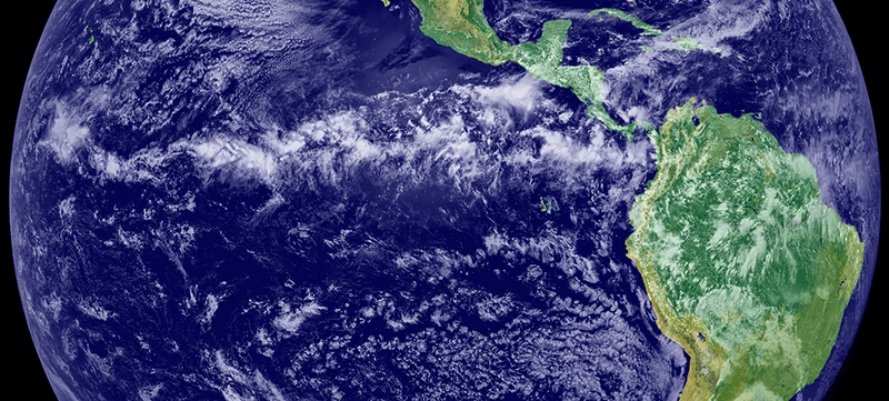 Band of clouds that circle the earth near the equator
(Source: http://earthobservatory.nasa.gov/IOTD/view.php?id=703)
What is creating this cloud girdle? The path of the sun, of course. When overhead, its rays warm the earth more intensely than they do when passing through the atmosphere at a more oblique angle. The hot tropical air rises with vigor, which, in turn, draws air in to replace it. In this way, winds are pulled from the northern and southern hemispheres toward the equator for several thousand miles. Laden with vapor swept up from the sea, these winds converge at the equator, causing them to switch direction from the horizontal to the vertical.[4] Rapidly ascending, this hot tropical air cools as it rises. The moisture it carries begins to condense and clouds arise in an earth-girdling ring of white. As it moves slowly along its westward path, this ring of moisture undulates north and south following the solar seasons. Passing over land masses along its way, these clouds release great volumes of rain, giving birth in the process to the rainforests of the Congo, the Amazon, Southeast Asia and Indonesia.
But the story does not end here. The rising air is not able to descend with the moisture it releases, since more air keeps pushing upward from below. At the top of its vertical ascent—where the upper boundary of the troposphere provides a barrier that keeps it from rising further—it streams laterally to the north and the south, creating a high-altitude divergence to complement the sea-level convergence below. Drying out on its poleward path, the air that rose up out of the ITCZ finally descends—bone dry—thousands of miles away at around 30 degrees north and 30 degrees south of the equator. This descending dry air is responsible for the desert belts—such as the Sahara, Kalahari, Mexican and Australian deserts—that we find at these latitudes. Like “two circulating doughnuts around the earth” (Volk 2003, p 69), this convection loop—which stretches from the equator one third of the way toward each pole—creates the wettest and driest regions of our earth! The two cells of this loop are known as the Hadley Cells[5] (see Fig. 2.3) (Ahrens 2012; Krump et al. 2009; Volk 2003).
 Figure 2.2. The Hadley Cells.
(Retrieved from www.newmediastudio.org/DataDiscovery)
Beginning in this way, we awaken in the students an awareness of the central role that the sun plays, not only in the alternation of summer and winter, of day and night, etc. but also in the overall physiology of the earth.[6] Even a brief glance at a map of Africa, for example, reveals three disparate landscapes that show a powerful contrast between wet and dry that can be attributed to the Hadley convection loops. These are the tropical rain forest, the desert biomes, and the savannas that lie between them. (James 1993; Henson 2002, Holdrege 2024).
Satellite map of Africa (Author: Koyos. Public Domain.)
(Screenshot from NASA’s globe software World Wind)
The pedagogical question for the Waldorf teacher now becomes: “how can we help the students experience such a large-scale process, one that extends 2000 miles to the north and 2000 miles the south of the equator? One approach that has proved effective is to look at the convection loop as a movement gesture, one which—it soon dawns on some of the students—is very much like one they know very well: the “L” gesture in Eurythmy. The “L” does just what we see in the Hadley Cells: converging below, rising up, diverging above and circling around to converge again below.
Diagram of “L” Gesture in Eurythmy
At this point we can ask the students if they would expect there to be related atmospheric patterns north and south of the Hadley Cells. We have discussed how warm air rises through the intense heat of the sun at the equator, but what about cold air? It sinks, as they know. The next question is: where might we expect to find descending cold air that would be the complement to the rising warm air at the equator? At the north and south poles, of course! If we imagine this concretely, it becomes clear that such descending air masses would have to diverge laterally when they reach the earth’s surface.
This results in a gesture similar to what we found when the cool, dry air of the Hadley cells descends at 30°, creating a gesture similar to the “T” in Eurythmy.
Converging and descending airflow patterns at the earth’s poles and at 30° north and south of the equator
If we focus, for simplicities sake, on the northern hemisphere for the moment, the next question we need to ask next is: what happens to the air that diverges southward from the “T” at the north pole, and what happens to the air that diverges northward from the “T” at 30°. It soon becomes clear to the students that without interfering factors the southward flowing air will eventually converge with the air ascending from the northern boundary of the Hadley cell, rising up and creating an “L” gesture similar to what we found at the equator—albeit under much cooler conditions. Indeed, if we imagine how this ascending air would—like in the Hadley Cells—need to diverge at the upper boundary of the Troposphere, we can now picture how it would circulate to the north and south, before descending again at the north pole, on the one hand, and at 30° latitude on the other. What we have done in our imagination is create a second convection loop in the northern hemisphere (the same would be the case in the southern hemisphere). If we put this into a drawing we see something like this:
The “Three-Cell Model” of convection loops converging and diverging from pole to pole
What has arisen following the dynamic discovered in the Hadley Cells and expanded to the entire earth is known as the “Three-Cell Model” in Geophysiology.[7] We now attempt to recreate this dynamic in movement gestures (without, of course, being able to imitate the curvature of the earth in this exercise). The students soon realize that they can demonstrate the overall pattern of the Three-Cell Model by lining up five individuals side-by-side doing “L”s simultaneously, the outermost descending arm of the students at the two ends of the row representing the poles of the earth, and the ascending gesture of the middle student representing the equator. They can also begin moving forward together, to represent how this pattern actually encompasses the entire earth, not just in the N-S direction that they are representing, but also from E-W. The ring of clouds we began with is created by the middle person’s ascending gesture, the descending gestures of that person and their neighbors create the desert zones at and S of the equator.
Various phenomena that underscore this three-cell atmospheric pattern are introduced to the students in this context. One popular example is the so-called “horse latitudes”, where the air descending more or less vertically (“T”) at approximately 30° north of the equator results in weak winds. History tells us that ships sailing to the New World were frequently becalmed in this region and, as food ran out, horses were thrown overboard or eaten.
After the students have developed a dynamic sense for the Three-Cell Model through Eurythmy-related movements, we explore further concepts (that can’t be expanded on in this short essay) connected with those movements: the Coriolis Effect, Pressure Gradient Force, high and low pressure systems, etc. These lead them, for example, to an understanding of why the prevailing winds in the mid-latitudes of the northern hemisphere move from East to West, and why in the northern hemisphere the descending air in a high pressure system curves clockwise (seen from above), while a low pressure system curves counterclockwise. We look at weather maps to see how these systems move from west to east (while vacillating north- and southwards) in the mid-latitudes and then try to recreate such movements using our Eurythmy gestures again. Some students wander along doing “L”s while rotating counterclockwise (to represent low-pressure systems) while others near them create high-pressure system “T”s. With time it becomes clear that these movements are even more complex. The students realize that the “T” gestures flow over into the “L” gestures when the diverge at the surface below, and that the “L”s flow over into the “T”s when they diverge up above.
Doing the “L” (low pressure) movements the students also experience how moisture is drawn up from the earth’s surface that will condense, create clouds and precipitation as it grows cooler, whereas the high pressure “T” spirals bring down the clear dry air from far above the earth that result in the beautiful blue-sky days everyone loves. From there we move on to how tornadoes and hurricanes form out of spiraling “L”s and how warm and cold fronts arise.
What has been described so far is only one example out of a multi-faceted inquiry into the geophysiology of the earth as it is revealed by the dynamic lawfulness of atmospheric and ocean currents.[8] The Eurythmy movements described above give the students a deepened sense for how dynamic—yet lawful—the earth’s atmosphere is, and awakens in them a capacity for recognizing similar gestures in other realms of nature.
For example, when they learn about the way that water naturally meanders as it flows through wide valleys, the students discover that within the general winding course of the water downstream a secondary spiraling circulation exists. One that is revealed by viewing the river in cross-section. Here they meet again the familiar “T” gesture. Briefly put: a double spiraling “T” dynamic gnaws away at the bank of the outer curves, while depositing sediment on inner side of the curve, before crossing over to the opposite bank and doing the same thing on the outer curves there.
“T” Loops create the curves of a meandering stream
Thinking back to the 9th grade geology block they now see how the primary dynamic behind plate tectonics with new eyes. Looking at diverging and converging plate boundaries, which are considered to be the primary movers in plate tectonics, one see the “L” (diverging) and “T” (converging) dynamic at yet another level of earth existence.
Tectonic plate divergence (mid-ocean ridge) and convergence (plate subduction)
When they move into their ecology block in the 11th grade, the students will see how this dynamic is expressed the seasons, in summer’s expansion and winter’s contraction, in the contrast between rainforest and desert, referred to above, and so on. They will begin to look at organisms like a tree from a more dynamic perspective. They will see, for example, how the expansive root system of the tree draws water from the dark and dense world of the soil below, brings it to convergence in the trunk of the tree, raises it up into the expanding network of branches and leaves above, before finally releases it (divergence) into the air and light-filled atmosphere above. On a hot sunny day, for example, a single mature maple tree will give off about 200 liters of water per hour into the atmosphere.[9]
Transpiration: water converges in the roots, diverges in the crown
On the other hand, they see how the life of the tree encompasses a contrary gesture, one that moves from the light and air-filled atmosphere down into the darkness and density of the soil. The leaves that have released the water into the sky can also do the opposite. Reminiscent of the converging “T” gesture, they take in light, warmth, and air (carbon dioxide) from the expanses above[10] and through photosynthesis create a much denser downward flow of organic compounds, much of which travels all the way into the subterranean darkness of the soil-entwined roots. There these substances (starch) are stored as a resource until the spring arrives and the tree’s primary growth period draws on them to unfold once more.
These examples are not meant to become fixed concepts of divergence & convergence, expansion & contraction, that are then sought out everywhere as a one-sided way of looking at things (cognitive bias), but rather—having been experienced in movement again and again—these Eurythmy-related gestures help the students become sensitive to the dynamic, yet lawful nature of living beings and systems. It helps them move beyond the static picture of a tree, for example, as a huge structure with a certain shape and yearly rhythm, into a sense for an organism that lives and unfolds in a never-ending process of expansion and contraction. They begin to experience the natural world less as one populated with “objects” (noun-like), and much more as a dynamic unfolding of lawful processes (verb-like) and patterns that we can develop a stronger sense for through dynamic movements such as the “L” and “T” discussed above.
Resources
Ahrens C. (2012). Meteorology Today. Pacific Grove, CA: Brooks/Cole.
Henson R. (2002). Weather. NY: Penguin Putnam.
Holdrege M. (2024). Ecology, Genetics & Ecology—Windows into the Dynamic Nature of Organisms.
Hudson, NY: Waldorf Publications.
James V. (1993). Africa’s Ecology. Jefferson, NC: McFarland & Co.
Kump et al. (2009). The Earth System. Upper Saddle River, NJ: Pearson, Prentice, Hall.
Volk T. (2003). Gaia’s Body—Toward a Physiology of the Earth. Cambridge: MIT Press.
Michael Holdrege (MS, MA, MBA) did his Waldorf teacher training in Stuttgart, Germany, before becoming a high school biology teacher at the Rudolf Steiner School in Vienna Austria, followed by 7 years at the Institute for Goethean Studies in Vienna. After returning to United States, he became a co-founder of the Chicago Waldorf High School, where he taught for 25 years. He currently teaches at the Waldorf Teacher Institute of Chicago and at the Waldorf High School Teacher Education Program in Wilton New Hampshire. He is the author of two books dealing with Waldorf life science teaching: From Mechanism to Organism—Enlivening the Study of Human Biology, which addresses 9th and 10th grade biology blocks, and Embryology, Genetics, and Ecology — Windows into the Dynamic Nature of Living Organisms, which discusses possibilities for 11th grade biology blocks. Both have their home at Waldorf Publications.
[1] For example, the New York Times (Sept. 22, 2022) reports that researchers have found a 27-fold increase over the past decade in the number of people experiencing an “extreme smoke day”—which is defined as air quality deemed unhealthy for all age group—caused by wildfires.
[2] For much more on how these issues are addressed in the 11th grade, see Holdrege (2024).
[3] When averaged over time on satellite maps.
[4] This region of the earth is therefore referred to by meteorologists as the Intertropical Convergence Zone (ITCZ).
[5] Three terms, in particular, highlight what is central in this context: convergence, divergence, and convection loop. Convergence indicates coming together; it often involves compression, compaction, concentration, contraction. Its converse, divergence, is centripetal in nature; it points to dissipation, dispersal, spreading out, expansion. The term convection loop makes evident that a connection exists between these extremes—it indicates that they are not separate phenomena, as such, but rather two poles of one and the same process.
[6] The 10th grade meteorology block usually covers a broad range of topics pertinent to the 11th grade ecology block, including the carbon cycle, greenhouse gases, and fossil fuel consumption.
[7] This model creates an idealized picture of how the wind and pressure patterns would unfold around a rotating water-covered earth that is not yet influenced by the warming, cooling, and other variables created by the presence of landmasses.
[8] After having planted their feet firmly on the “solid” earth below in the 9th geology block.
[9] 90% of the water that reaches the atmosphere from land comes from plant transpiration. The Amazon basin rainforest transpires 20 billion tons of water into the atmosphere each day.
[10] It is estimated that tropical forests remove 1.3 to 2 billion tons of CO2 from the atmosphere annually.
 Michael teaches Life Sciences in CfA’s Waldorf High School Teacher Education Progra, (WHISTEP)
Reprinted from: Research Institute for Waldorf Education; Research Bulletin Volume XXIX, 2025